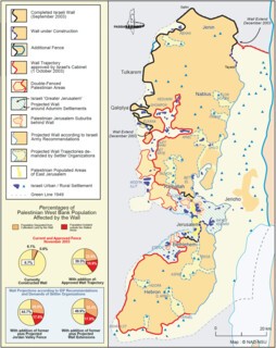
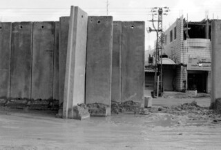
It was on the way up to Qalandya, on the edge of metropolitan Jerusalem, that I got my first glimpse of the separation barrier. In the neighbourhood of al-Ram, large sections of the wall that Israel began building in 2003 have recently been erected, although gaps still exist towards the northern edge of the district.
As the construction of the wall north of Jerusalem enters its final phase, it has become clear that the 50,000 Palestinians in and near al-Ram will be entirely surrounded, cut off from each other and the outside world. Nearby, the wall will also isolate 70,000 Palestinians in and around Bir Nabala – people who already live between sections of wall in al-Ram to the east and al-Jib to the west, and have the Beit Hanina checkpoint to the south of them and the notorious Qalandya checkpoint to the north.
At one point, to stay on the west side of the wall, we had to drive along a pockmarked strip of road directly beneath it. Other Palestinians, most of them on foot, were picking their way among the potholes, trying to avoid being spattered with mud or hit by passing vehicles.
At the Qalandya checkpoint, there was a massive traffic jam of taxis, cars, buses, minivans and trucks. Some were trying to find a place to park; others to get out of the parking spaces they had been wedged into. Hundreds of people were milling about: women, children, men carrying boxes and suitcases, farmers carrying crates, merchants carrying loads of material, all hoping to find cars or buses or trucks to their final destinations – or, more likely than not, just to the next checkpoint, where they would have to go through the whole thing again. ‘Nablus! Nablus! Nablus!’ some drivers were calling out, offering rides there. ‘Beit Lahem, Beit Lahem,’ over here, for rides to Bethlehem; ‘al-Quds, al-Quds,’ over there, for Jerusalem. Somewhere in the sea of cars and people I found Hani, the driver who had arranged to take me on the next stage of my journey.
As Hani and I set off for Qalqilya, I worried whether the green West Bank licence plates on his car would cause us problems. Jerusalem residents have yellow Israeli plates, and so fare better at roadblocks and avoid routine army searches altogether. ‘These days, it’s not so bad,’ Hani assured me. ‘A few months ago things were terrible; we couldn’t move around at all, but the army’s recently relaxed its grip. That’s what they do: they throttle you so hard that you’re about to die, then they relax so it only hurts: there are still checkpoints and roadblocks, searches and harassment, but because you can kind of get around, it doesn’t feel so bad.’ He told me the road we were on was normally classified as a ‘restricted road’. Until a few months back, we wouldn’t have been allowed on it with West Bank plates. ‘But as long as the “loosening” lasts,’ he explained, ‘we can use this road. Provided we have the appropriate permits and our papers are in order.’
The operating principles of the Oslo Accords have greatly facilitated the Israeli stranglehold on Palestinian life. Oslo split the Palestinians in the West Bank into what the agreement defined as Areas A, B and C. Area A consists of the major Palestinian cities, like Nablus and Ramallah, which reverted to nominal Palestinian control under the agreement – but it amounts to only 18 per cent of the West Bank. Area C, under full Israeli control, amounts to more than 60 per cent, and Area B, which is under Palestinian administration but Israeli security control, to another 22 per cent. All the bits and pieces of Areas A and B are cut off from one another, islands completely surrounded by Area C. Oslo gave Israel a free hand over Area C until final status talks – which were never arrived at – could be successfully concluded. It was partly as a result of this that the Israeli building of colonies and roads continued feverishly throughout the so-called negotiations. In 1995 alone, Israel added 100 kilometres of new roads to the West Bank: 20 per cent of all Israeli road-building in that year. And the more Israel consolidated its hold on Area C, the more the Palestinians were forced to find ways around the roads from which they were excluded – the Israelis call them ‘sterile’ roads. Hani would periodically point out the dusty tracks on the hillsides which Palestinians have to use to get from village to village, since many Palestinian towns aren’t adequately linked to main roads (again, this is neither oversight nor coincidence). There are two semi-independent road networks in this tiny territory: the elaborate, well-paved, well-signed, well-marked and well-lit Israeli one, and the broken, potholed, discontinuous, repeatedly interrupted and regularly blockaded Palestinian one. In order to complete the separation of the Israeli and Palestinian road systems in the West Bank, Israel is planning a system of bridges and tunnels that will link the fragmented Palestinian areas while allowing Israeli traffic to cut through the West Bank on ‘sterile’ roads. The army likes this idea because it will in the future be possible to stop communication between the Palestinian areas simply by opening and closing a few of these bridges and tunnels. The whole thing is designed to look as if it makes life easier for the Palestinians, while actually facilitating the occupation for the Israelis.
In January 2004, according to the UN Office for the Co-ordination of Humanitarian Affairs (OCHA), there were 59 permanent Israeli checkpoints in the West Bank, ten partial checkpoints, 479 earth mounds, 75 trenches, 100 roadblocks and 40 road gates, all designed to disrupt or halt the circulation of Palestinian traffic. All Palestinians need permits to travel around the West Bank (which was not the case before Oslo). Getting a permit requires a lengthy administrative procedure, and tens of thousands of requests from Palestinians who for one reason or another are deemed ‘security risks’ are flatly denied. The vast majority of permits issued are for pedestrians or passengers on public transport. Of more than two million Palestinians in the West Bank, only 3000 have permits to drive their own vehicles. Hani’s car belonged to the organisation he worked for. In any case, even Palestinians with permits have to contend with the grid of Israeli checkpoints, and their random opening and closing.
On the way to Qalqilya, we passed Palestinian towns and villages whose access roads had been blocked by the army with piles of earth or boulders. At each one there were parked cars and vans, or people waiting. The Jewish colonies we’d seen were very different. Invariably set on the highest hilltops, with grid layouts, chalet houses, woods and gardens, they presented a radical visual contrast to the parched communities beneath them. The settlements had wide, well-lit and beautifully paved access roads.
Qalqilya has a population of about 60,000 and is itself a major agricultural town, surrounded by fields, orchards, greenhouses and olive groves. Like other large Palestinian towns, it used to serve as a commercial and administrative centre for the towns and villages around it, whose combined population is another forty or fifty thousand. Because Qalqilya also lies beside the so-called Green Line that is supposed to separate the West Bank from Israel – a nominal border which is being made almost meaningless by the construction of the separation barrier, 90 per cent of which runs east of the Green Line, deep into the West Bank – it used to be possible for Palestinians from neighbouring towns inside Israel to go to the market there or meet friends and relatives. Israel’s separation barrier has destroyed a complex of historic, commercial, agricultural, social, cultural and familial relationships. Despite the talk of this being a ‘security fence’, it is obvious that the real aim of the barrier is to absorb as much land, and as few Palestinians, as possible, to acquire pockets of territory that can easily be connected – and are already de facto annexed – to Israel. Nowhere is this clearer than in the well-watered and fertile agricultural region around Qalqilya. North of the city, the barrier absorbs about 6000 acres of rich farmland. Qalqilya is now the westernmost tip of a territorial peninsula created by the barrier.
Qalqilya, and Tulkarem to the north, as well as another twenty or so towns and villages in the same area, now find themselves separated from their agricultural land by the network of walls, electric fences and ditches that make up the separation barrier. What’s worse, another six or seven Palestinian towns are wedged between the separation barrier and the Green Line. These cases are all in the immediate vicinity of Qalqilya, but the same sort of thing is happening all along the barrier.
In October 2003, soon after the erection of the barrier began, the army declared the land between the barrier in the east and the Green Line in the west a ‘closed military area’. The declaration states explicitly that no one can enter the closed area other than Israeli citizens and anyone to whom Israel’s Basic Law of Return applies (that is, anyone of Jewish extraction from anywhere in the world). ‘No one’, in other words, means those Palestinians whose land has been – or is about to be – taken from them. The inhabitants of the villages in the ‘closed area’ have to apply for a ‘permanent resident permit’ from the army. As its name suggests, this is something like a US Green Card, except that in this case the person applying for the permit wants only to be allowed to stay where he has lived all his life. The permits can be withdrawn or cancelled at any time, which means in effect that the people in this area are subject to summary expulsion from their land and homes whenever it suits the state of Israel. In the area around Qalqilya, several thousand Palestinians have permanent resident permits. When the barrier is completed, however, around 100,000 Palestinians will find that they need them. And tens of thousands of others will find themselves cut off from work, schools and healthcare (a third of the West Bank’s villages will have problems in getting access to healthcare once the wall is completed – 26 clinics have already been cut off, and that number will rise to 71 once the wall is finished).
Those Palestinians who live outside the closed area, separated from their farmland and orchards inside it, aren’t much better off. Palestinian farmers from Qalqilya, Jayyus and the surrounding villages who want to cultivate their land on the other side of the barrier must obtain permits from the occupation forces. Israeli military regulations specify up to a dozen different types of permit that Palestinian farmers need to apply for in order to reach and cultivate their land. Of course, in order to get these permits, a complex series of bureaucratic and administrative hurdles needs to be cleared. If there are errors in the original registration of the land, or if the original owner has died or moved overseas, or if there are any questions about inheritance or the reallocation of land among or between families, or any questions about bills of sale or titles – that is, if there are any of the legal problems associated not merely with land ownership in general but, in particular, with ownership of land whose legal documentation has passed through countless municipal offices under four different administrations (the Ottoman Empire, Britain, Jordan, Israel) – then the application for a permit will be suspended.
Much of the land in the West Bank has, in any case, never been formally registered by any of these governing bureaucracies, and is instead held informally, or, rather, in accordance with premodern, customary laws of land ownership and usage (including collective usage, such as grazing). To deal with this problem, the Israelis have dusted off the 1858 Ottoman Land Law and, applying their own highly selective interpretation of it, have declared much of the Palestinian-held land in the West Bank ‘state property’, or classified it, using the Ottoman terminology, as ‘miri land’, the ownership of which is tied to its productive use. According to Israel’s interpretation, miri land that is not actively cultivated for a certain period of time (even if its cultivation is being forcibly prevented) reverts to public ownership – which, as far as the Israelis are concerned, means they can do what they want with it. The only snag is that the Ottoman Empire expired with the Treaty of Sèvres, and so never signed up to the UN Charter or the Geneva Convention – both of which have stipulations regarding occupied territory – and Israel did. In any event, while the various legal issues are contested, much of the land will lie unused, and the clock will start ticking: this is the way the Israelis have used the miri land laws in the past to expropriate Palestinian territory.
So far, about a quarter of the applications for permits to gain access to land in the closed area have been rejected by the occupation authorities. Even those who receive permits do not necessarily manage to get to their land, since this also entails passing through a number of gates that the Israelis have built into the separation barrier, in reluctant response to protests. In the ‘seam area’ between Qalqilya and Tulkarem, for example, there are 12 gates, four of which have never been opened to Palestinian farmers, while a further three have been designated for purposes other than agriculture, and are also off limits to farmers. That leaves five gates. The gates closest to the northern edge of Qalqilya are among the ones that have never been opened or are not to be used by farmers, so any farmer living in Qalqilya whose land lies a little way to the north must leave the city along the road to the east (which is now open, but may be closed again at a moment’s notice), and, running the gauntlet of checkpoints and roadblocks, make his roundabout way to the east and then the north before reaching his land.
Or, rather, before reaching the gate closest to his land. During the months after the permit system came into effect, farmers had to wait for long periods before getting through. At the beginning of the 2003 olive harvest, the gates did not open at all for weeks as a collective punishment for a bombing in the city of Haifa.
Following a number of appeals and petitions to Israel’s high court, most of the gates – or rather, most of the five gates available to farmers – now operate on a more or less fixed schedule, opening three times a day, for half an hour at a time. Even so, plenty of problems remain for Palestinian farmers. They often cannot take their tractors and farm machinery through the gates; at peak times, such as harvest, it’s hard for them to bring through extra labour because the new hands might not have the right permits, and a day or a week or a month going through the nightmare of obtaining permits is a day or a week or a month away from the fields. And assuming that by a concatenation of miracles all goes well for a Palestinian farmer, he must still get his crop to market, which involves finding an open gate, getting his produce through that gate, half an hour at a time, negotiating roadblocks, obtaining transportation permits, waiting at the checkpoints that can hold up perishable produce for hours or days, and organising serial, or ‘back-to-back’, transport to get the goods from checkpoint to checkpoint without actually driving through each one (often prohibited). According to the most recent World Bank assessment of the Palestinian economy, ‘the “back-to-back” system for the transit of non-humanitarian goods’ – which requires unloading and loading the produce at each checkpoint – ‘became routine in 2003.’ But a day or a week or a month of closure or curfew would spell disaster.
Along the western edge of Qalqilya, the separation barrier takes the form of a 24-foot concrete wall. Along the northern side and the southern side, the road that used to take farmers to their fields is now interrupted by the usual mound of earth and concrete cubes, a metal gate, rolls of razor wire about three feet deep, a ten-foot wire grate topped by more razor wire, fifty yards of roadway, more razor wire, an electric fence, more razor wire, another fifty yards of roadway and then, on the other side, more of the same. All this is protected by an immense fortified tower, with the Israeli flag hanging from it. I was told, as I surveyed the Israelis’ efforts here, that I was standing in what had once been an orchard, but the trees had been cut down to maintain a clear line of sight from the tower.
It isn’t just that so much damage has been done to a relatively small area – although a swathe of permanent devastation 200 metres wide by eight kilometres long in a town the size of Qalqilya is already more than a poor community can sustain – but that the expropriation clock is now ticking on the Palestinian land here that isn’t being watered or tended because it can’t be.
The resumption of negotiations between the new Palestinian leadership and the Israeli government has generated a sense of optimism that one hesitates to dismiss out of hand. Yet previous rounds of negotiation, beginning with Oslo, served only to consolidate Israel’s grip on the West Bank, Gaza and Jerusalem, while making life even more difficult for the Palestinians. In the same way, the lull that followed the death of Arafat in November was seen by many as a time of hope, but it was then that the people of Jayyus, near Qalqilya, learned that more of their land would be expropriated in order to make possible the expansion of the Israeli colony of Zufim, in the ‘seam area’ between the Green Line and the barrier. Their olive groves were bulldozed in December. Blind optimism that overlooks these ‘facts on the ground’ is no better than despair.
Send Letters To:
The Editor
London Review of Books,
28 Little Russell Street
London, WC1A 2HN
letters@lrb.co.uk
Please include name, address, and a telephone number.


