Last June, Nasa and the Japanese Ministry of Economy, Trade and Industry published a detailed topographic map of the Earth, covering an unprecedented 99 per cent of the planet’s landmass. The map was compiled from data collected from a Japanese radiometer on board an American spacecraft; the elevation measurement points are only 30 metres apart. According to Nasa, the data ‘fill in many of the voids … such as in very steep terrains and in some deserts’. Anyone can look at it online for free. It would seem that now there really is no uncharted territory left on the surface of the Earth. If you wanted to set out exploring unknown terrain with a map that could still even half-plausibly claim ‘here be dragons,’ you’d have to go deep underwater, deep underground or into deep space.
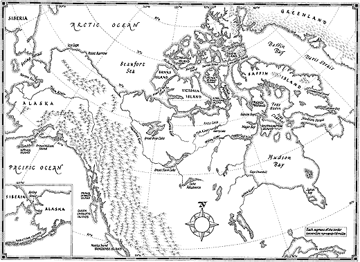
The Nasa/METI map is a triumph of 21st-century technology and international co-operation. But amazing though it is, it’s in some ways less impressive than its distant pre-Sputnik ancestors, the new maps that could only be made by sending men beyond the edges of the old maps. Glyn Williams’s Arctic Labyrinth: The Quest for the Northwest Passage is an engrossing account of four centuries of exploration, as expedition after expedition tried to negotiate a course through the vast, multitudinous, close-set and ice-locked archipelago to the north of the American continent.
The ice is now melting: within 25 years the Arctic Ocean will probably be entirely free of ice during the summer; some climate researchers believe it could happen as soon as 2013. (Mapping the effects of climate change is one of the purposes of the Nasa/METI project.) Among the possible consequences are the extinction of polar bears; the end of the Inuit way of life; rising sea levels worldwide; and a territorial stand-off between Canada and the United States, which disagree about whether the maze of straits intersecting the archipelago count as international waters or sovereign Canadian territory (no longer an academic question, once the northwest passage is open). Some of the effects that an open Arctic Ocean may have on international relations, energy security and global trade are explored in The Future History of the Arctic by Charles Emmerson.* But the idea that a thawing Arctic is something to be afraid of would have baffled our ancestors. For the men who sailed from Europe in search of a northwest passage, and for the men who sent them, the ice was what there was to fear, and a summer warm enough to melt it was often the only hope for survival.
The same wishful thinking that led people to believe there had to be a way through the ice, if only because they wanted there to be one, must in part explain the oddly persistent belief that if you went far enough north the ice would give way to an open polar sea. Williams reproduces a beautiful but fanciful map made by Mercator in 1569 that shows the North Pole as a large rock (an iron-rich mountain at the pole was one way of explaining why compass needles swung towards it) in the middle of an open sea surrounded by four islands with convenient channels between them. On Mercator’s map, there’s an obvious sea route from Europe to Asia up the west coast of Greenland, along the northern edge of North America, and south through a channel called the Strait of Anian, which seems to have been the hopeful invention of a Venetian cartographer, Giacomo Gastaldi, a few years earlier.
The first Englishman to try to navigate this route was Martin Frobisher, privateer, adventurer and blagger extraordinaire, who set sail from Gravesend in June 1576 with 34 men in three lightly equipped and, as Williams puts it, ‘alarmingly small’ boats. The expedition was financed by a group of 18 investors who called themselves the Company of Cathay. Two years earlier Elizabeth I had rejected a plan for a voyage through the Strait of Magellan: one of the great advantages of a northwest passage, besides the shorter distance, would be its remoteness from Spanish spheres of influence. And a northeast passage had already proved impossible: in 1553, the last year of the reign of Elizabeth’s brother, Edward VI, an English expedition had tried to sail to China round the north of Russia. Most of the sailors froze to death near present-day Murmansk, but some of them made it to Moscow, where they struck a trade deal with Ivan the Terrible – nearly as good as a sea route to Asia, if not better.
After losing five men and a boat, either (as he thought) to an Inuit trick or to the bad weather, and in the face of heavy snow, Frobisher turned back. He claimed to have discovered the entrance to the passage, which he called Frobisher’s Straits; in fact he had penetrated a hundred miles or so into an inlet on Baffin Island now known as Frobisher Bay. But he also appeared to have found something even better: a gold mine. He led another expedition the following year and returned to England with 200 tonnes of ore that his men had ‘dug out of the frozen earth’, in Williams’s words, ‘with agonising toil’. It was found to contain little or no trace of precious metals.
By this point the scheme was too big to fail – too much money and hope had been invested in it – so instead of abandoning it as a lost cause Frobisher led a third, even larger expedition in 1578: if the ore wasn’t as rich as they’d hoped, then they’d simply need more of it. The plan was to establish a mining colony, never mind that the chosen site was ‘one of the most desolate and inaccessible parts of the North Atlantic basin’. A permanent settlement proved impossible, however, and within a couple of months Frobisher was back in England with 1250 tonnes of ore, having lost two ships and 40 men. By any measure, it wasn’t worth it. The only shiny substance extractable from the ore was iron pyrites (fool’s gold).
The pattern of hope, distraction, disappointment, hope renewed and further disappointment repeated itself many times over the centuries that followed. Great strides of one sort or another were made, not all of them expected: cartography, the fur trade, the study of geomagnetism and literacy in the navy were all variously advanced by the otherwise quixotic search for a northwest passage, but no reliable way through the ice was found. The pendulum of opinion, meanwhile, among both experienced seamen and armchair navigators, swung between belief that a passage existed and conviction that it didn’t. The more southerly part of the body of water to the west of Greenland is called Davis Strait; it runs north into Baffin Bay. In 1585, on returning from his first voyage to find the passage, John Davis wrote to Francis Walsingham that ‘the northwest passage is a matter nothing doubtful.’ Thirty years later, William Baffin wrote to one of his financial backers that ‘there is no passage nor hope of passage.’
Baffin did see a lot of whales though, and most of the ships that sailed to the Arctic from Europe in the 17th century were whalers, heading ever further westwards as the whale populations to the east were hunted to extinction. The other great commercial offshoot of the search for a passage was the Hudson’s Bay Company, established in 1670 to exploit the potential of the North American fur trade. Henry Hudson had discovered the vast body of water in Canada’s northeast that bears his name 60 years earlier, in the summer of 1610. (The previous year, exploring further south, he had sailed from New York Bay up what we now call the Hudson River to where Albany now is, at which point he realised that it wasn’t after all a route to the Pacific.) After safely negotiating the 400 ice-choked miles of what’s now known as Hudson Strait, Hudson imagined that he was on the far side of the continent, and that it would be a simple matter to sail southwest to the Pacific coast of North America. By early November, after three months of ‘aimless wandering’, his ship, the Discovery, was frozen in.
No expedition in search of the northwest passage had yet spent a winter in the ice. Hudson wasn’t very far north – around 51º, the latitude of London – but even so wasn’t able to set sail until June the following year. As well as the cold, the crew had extreme hunger to contend with: reduced at times to eating frogs and lichen, many of them developed scurvy. Fearful that Hudson would keep trying to find the passage instead of sailing for home, they mutinied. Hudson, his son, half a dozen sick men and the ship’s carpenter (who went voluntarily, refusing to take part in the mutiny) were thrown off the Discovery and set adrift in a small boat. ‘Hudson’s little party might possibly have survived the summer months on shore but not the following winter,’ Williams writes. ‘They had been callously sentenced to a lingering death.’ As for the mutineers, a few of them, including most of the ringleaders, were killed not long afterwards by Inuit. The Discovery more or less drifted east across the Atlantic, to limp home up the Thames in September 1611. With its leaders dead, the authorities were much less interested in the mutiny than in the implications of Hudson’s discoveries: had he found the entrance to the northwest passage or hadn’t he?
Most of the intermittent attempts to find a passage over the course of the next 200 years concentrated on looking for a way to the west out of Hudson’s Bay. (There isn’t one.) A lot of effort was expended in the exploration of river mouths and inlets that led nowhere; a lot of faith was put in the direction from which the tide appeared to come, wrongly supposed to be an indicator of a large waterway to the west. Other expeditions thought they might have more luck approaching the passage from the Pacific end. As Williams says, ‘there was nothing new about the idea’: Francis Drake may have been looking for the passage when he took a long detour up the coast of California during his circumnavigation of the globe in the late 1570s, shortly after Frobisher’s forays on the Atlantic side.
In the early 18th century, America’s Pacific northwest was still terra incognita to Europeans: when Swift chose the region as the location for Brobdingnag, none of his readers could have said for sure that the land of the giants wasn’t really there. That changed with the voyages of Vitus Bering, James Cook and George Vancouver, who between 1728 and 1794 mapped out most of the west coast of Canada and Alaska. They were looking for a strait and an inland sea supposedly discovered by Juan de Fuca and Bartholomew de Fonte in 1592 and 1640. Unfortunately, the Spaniards’ voyages had no more basis in fact than Gulliver’s did, as Cook and Vancouver proved. ‘The surveys of the 1790s marked the end of an era,’ Williams writes, ‘for after three centuries it was at last clear that no northwest passage existed that could provide a practicable route for sailing ships.’
That didn’t deter the British for long. Just because there wasn’t a way through at temperate latitudes didn’t mean there wasn’t one further north. In 1818, with the Napoleonic Wars over, two expeditions were simultaneously sent out by the Admiralty, with the support of the Prince Regent and large financial rewards promised by Parliament for even partial success. John Ross was to look for a northwest passage through Baffin Bay; David Buchan was to head north past Spitsbergen, with luck into the open polar sea and out the Bering Strait into the Pacific. On 29 August, Ross entered Lancaster Sound, north of Baffin Island. If only he’d known it, he’d found the way into the northwest passage. But two days later, convinced he had seen a ‘connected chain of mountains’ blocking the way ahead, he turned back. ‘No convincing reason for his mistake has ever been produced,’ Williams writes. Buchan had turned back too, his way actually blocked by pack ice just north of the 80th parallel.
Undaunted, the following year the Admiralty sent another ‘double-pronged effort’, under the leadership of Ross’s and Buchan’s lieutenants, Edward Parry and John Franklin. Parry’s mission was to take another look at Ross’s mountain range, which no one else on his ship (not even Parry) had seen. Franklin was to head overland from a Hudson’s Bay Company trading post down the Coppermine River to the Arctic coast of the continent, to ‘complement the process of seaborne discovery by locating the southern shore of the northwest passage’. It sounded so easy on paper.
Parry’s expedition was the first to spend a winter north of the Arctic Circle. They dropped anchor on 26 September in a bay off Melville Island, midway between the Atlantic and Pacific Oceans, and further west than any European had yet sailed in those latitudes. The sun set on 4 November, and didn’t rise again until February. In January the temperature dropped as low as -54ºF. ‘As depressing as the darkness was the feeling of complete isolation,’ Williams writes: they were 1200 miles from the Danish settlements on the coast of Greenland, further than that from a Siberian port, 750 miles from the nearest fur-trading post and hundreds of miles even from any Inuit settlements. But Parry did his best to keep his men healthy and occupied: there was regular exercise, lemon juice and sauerkraut to ward off scurvy (not entirely successfully), music and dancing, reading and writing lessons, a weekly newspaper and fortnightly plays put on by the officers to entertain the men. The officers also kept themselves busy making scientific observations. All in all, better than freezing to death or dying of boredom, but still no way to spend Christmas. The ice didn’t release the ships until 1 August: running low on supplies, knowing another winter would be impossible, Parry headed for home. They reached England at the end of October. In nearly 18 months at sea, only one crew member died – and he was found to have had diseased lungs before they sailed.
By contrast, Franklin’s three-year trek down the Coppermine River, along the coast and back again was a disaster. With no prior experience of Arctic land travel, underequipped but overburdened, plagued by mosquitoes in the summer, freezing in the winter, overbearing to the point of incompetence in his dealings with French-Canadian voyageurs (canoemen), as well as with Native American and Inuit guides and translators, Franklin was lucky to survive. He was saved from starvation on the return journey only by the efforts of one of his men, George Back, who went on ahead to ask for help from the Yellowknife Indians they’d encountered on the way north. In Williams’s assessment, ‘some of the expedition’s misfortunes can be attributed to factors beyond Franklin’s control,’ and he ‘showed infinite courage and willpower as he refused to give up what seemed a hopeless quest to reach safety, but his inflexibility and his unfamiliarity with conditions in the far north were serious handicaps.’
Andrew Lambert, in his new biography of Franklin, an attempt to reclaim the explorer from both Victorian hagiography and subsequent disparagement, is less even-handed: ‘Whatever else had been achieved, Franklin had demonstrated a rare talent for leadership.’ Maybe. Twelve men had died under his command. Still, the British public were impressed by him, especially when his account of his adventures came out in 1823, and he was soon widely known as ‘the man who ate his boots’. The authorities were no less pleased: he was promoted within the navy and elected a fellow of the Royal Society, and plans were soon underway for him to lead another expedition.
In 1825-26 he travelled down the Mackenzie River, which flows into the Arctic Ocean a few hundred miles west of the Coppermine, and then trekked 600 miles further west along the coast. ‘The second mission profited from the bitter experience of the first,’ Lambert writes. ‘It was essentially incident-free … This time Franklin knew what to do, what to take, and whom to trust … Once again Franklin provided a master class in navigational skill, science and leadership.’ There was one ‘incident’, when they encountered a group of Inuit who started helping themselves to the Europeans’ supplies. According to Lambert, ‘Franklin’s calm, judicious and thoughtful conduct saved the expedition: if anyone had fired a gun they would all have died.’ Williams, too, praises Franklin’s ‘firmness and diplomacy’, but also gives credit to ‘the negotiating skills of Augustus’, the Inuit interpreter (his real name was Tattanoeuck; Lambert doesn’t call him anything).
Despite the success of the expedition and Franklin’s repeated requests to be sent back to the Arctic, his next postings were to the south: first on naval service in the Mediterranean, then to Hobart as lieutenant-governor of Van Diemen’s Land. It was a grim commission, and Franklin’s efforts to mitigate the brutality there, for all Lambert’s efforts to portray them in a positive light, were woefully ill-conceived: a school modelled on Thomas Arnold’s Rugby, the Tasmanian Philosophical Society and Tasmanian Journal of Science may have been worthy enterprises in their own right, but they were hardly suited to a penal colony largely populated by illiterate convicts. Franklin would have done better to follow Parry’s example and offer a few basic reading and writing classes. However good his intentions, his insistence on imposing his will and his refusal to adapt to his circumstances, both in the Arctic and in the Antipodes, were considerable flaws.
After being recalled early from Hobart, dismissed for not being able to balance the budget, Franklin was finally granted his wish to lead another expedition to the Arctic in 1845. Nearly 60 years old, overweight and unfit, he wasn’t an ideal candidate. But the Admiralty’s first choice, James Clark Ross, who had sailed with his uncle John in 1818 and with Parry in 1819, and was just back from a four-year voyage to the Antarctic, turned them down. The Erebus and Terror set sail under Franklin’s command in May 1845 with 133 men on board. Apart from four who were invalided home from Greenland, within three years all of them were dead.
It wasn’t unusual for expeditions not to be heard from for a year or two: in the 1830s John Ross had disappeared for four years and come home safely. The first search and rescue expeditions were sent out after Franklin in 1848; the hunt for him, thanks in no small part to the tireless lobbying of his widow, Lady Jane, soon came to supplant the search for the northwest passage as the primary purpose of voyages to the Arctic. Lambert argues, fairly convincingly, that by the time of Franklin’s voyage the search for the passage was itself a crowd-pleasing pretext, and that the ‘real object’ of the expedition was to make observations of magnetic variation (the extent to which a compass needle points away from true north) as close to the Magnetic North Pole as possible. Williams (who thanks Lambert for lending him his research notes, so wasn’t unaware of the thesis) thinks that the scientific observations were a secondary objective. Presumably, then as now, what the main purpose of a voyage was depended on who you talked to.
Whatever their aim when they set out, the crews of the Erebus and Terror were soon focused on one thing: survival. According to documents recovered in 1859, Franklin himself died on 11 June 1847, the ninth officer to perish. The ships were abandoned on 22 April 1848. Contemporary Inuit reports and forensic evidence gathered from bones discovered in 1992 suggest that within a month the remaining men were relying on the bodies of their dead comrades to fend off starvation. Lambert makes quite a big deal out of the cannibalism, opening his book with a sensational account of it: ‘We do not know if they killed the living, picking out the weak, the young and the expendable, or whether they confined their attentions to the dead. But make no mistake they ate their shipmates.’ And so on. Williams, more wisely, doesn’t get so excited. Given the unimaginable hardships endured even by those who made it back alive from the Arctic, it shouldn’t be especially shocking or even surprising that freezing, starving men, with nothing else to eat within hundreds of miles, should have resorted to the only meat available to them. Of course, when the reports of possible cannibalism reached England in 1854, there was plenty of outrage and denial. Jane Franklin was furious; Dickens rose to the occasion in Household Words, dismissing the story as ‘the vague babble of savages’.
The only stories most people wanted to hear were heroic tales of derring-do and self-sacrifice. Quite a cult developed around Franklin, with his widow as its high priestess: no longer merely the man who ate his boots, Franklin came to be celebrated as one of the empire’s great pioneers. In 1866 an eight-foot high bronze statue proclaiming him the discoverer of the northwest passage was unveiled in Waterloo Place. ‘They forged the last link with their lives,’ it says. Maybe they did, maybe they didn’t. Either way, ‘forging the last link’ isn’t quite the same thing as successfully navigating the entire passage in one voyage (and without dying).
The first person to do that wasn’t British but Norwegian. In 1906, Roald Amundsen, five years before he beat Scott to the South Pole, accomplished the first complete transit of the northwest passage. He took six men and five years’ supplies with him in a small, shallow-draught herring boat. His success was largely down to his sensible methods – what Roland Huntford, the author of Scott and Amundsen, has called his ‘meticulous planning and complete lack of a sick desire for heroic suffering’ – and his willingness, in contrast to Franklin, to adapt to his environment. For travelling overland, ‘unlike most of his British naval counterparts’, who, like Scott in the Antarctic, foolishly insisted on dragging their sleds themselves, ‘he copied Inuit methods of travel,’ Williams writes: ‘their use of dog-teams, their building of snow houses while on the trail, and not least their clothing’. Even so, it took Amundsen three years. In the century since then, the passage has been successfully navigated by several icebreakers and an undisclosed number of nuclear submarines. But as the thaw accelerates, the northwest passage may yet become the trade route it was once hoped to be.
So why did they keep at it, those crazy Englishmen, for so long? As with the moon landings – the later 20th century’s nearest equivalent to the polar missions of a previous era – it was possible to give any number of strategic, commercial, scientific, even aesthetic reasons for sending expedition after expedition into the Arctic wastes. But none of these motives, and no combination of them, seems quite adequate to account for the vast amount – of energy, money, suffering, life – expended over the centuries on the search for a northwest passage. Perhaps the ultimate explanation was a variant on that rote justification of mountain climbers: because it wasn’t there.
Send Letters To:
The Editor
London Review of Books,
28 Little Russell Street
London, WC1A 2HN
letters@lrb.co.uk
Please include name, address, and a telephone number.