Salmon Fishing in London
Anna Aslanyan
The Tyburn Angling Society purports to have been established by a royal charter issued by King Edgar the Peaceable in 959 AD, though there are no records of its existing before the 21st century. The River Tyburn, culverted in 1750, still flows underground from Hampstead to Westminster. The society claims to want to ‘daylight’ the river, bringing it back up to the surface. It commissioned a map in the early 2000s showing the proposed course, which would cut a swathe through ‘£1 billion worth of property’. The buildings marked for demolition included Buckingham Palace and the offices of Westminster City Council, which promptly rejected the proposal.
In 2011, another plan, to restore the river’s course through Regent’s Park, looked slightly more plausible as Boris Johnson, then the mayor of London, indicated ‘a degree of support’. ‘The world is full of doubters,’ James Bowdidge, ‘the honourable secretary of the society and a former property developer’, says in a video on display at the Museum of London’s Secret Riversexhibition in Docklands. CGI images showing what the West End might look like if the Tyburn were converted into a ‘premier salmon river’ could come straight out of a luxury property brochure.
Rivers have long been part of gentrification processes in London. After the Great Fire, Christopher Wren had an idea for widening the Fleet to create a ‘new Venice’ near St Paul’s. ‘Wren didn’t have CGI futurism as a tool, ersatz utopianism,’ Iain Sinclair writes in Swimming to Heaven: The Lost Rivers of London (2013), ‘but he did have drawings that suggested Fleet-as-Venice would become a wonder of the age.’ Instead, the river soon became a ‘source of filth and corruption’ – ‘Fleet-ditch with disemboguing streams,’ Pope wrote in The Dunciad – and was covered over in the 19th century. In the 1860s both the Fleet and the Tyburn became part of Joseph Bazalgette’s sewer system.
South of the Thames – washed by the Neckinger, the dirtiest river of all – was Jacob's Island in Bermondsey, where sewage was a constant presence. In 1849 the Morning Chronicle called it ‘the Venice of drains’; on a map made at the time ‘shewing the mortality from cholera in each registration district’ it’s a black spot . Tanning pits releasing waste into the Thames through a network of ditches added to the area’s unhygienic conditions.
Bill Sikes meets his end in Oliver Twist in the slums of Jacob’s Island. Dickens describes them as ‘surrounded by a muddy ditch’; when the water is high, ‘the inhabitants of the houses on either side’ can be seen ‘lowering from their back doors and windows, buckets, pails, domestic utensils of all kinds’. Some of these are on display at the Museum of London, alongside a bone toothbrush (though the 19th-century residents of Bermondsey rarely brushed their teeth, and when they did they mostly used soot).
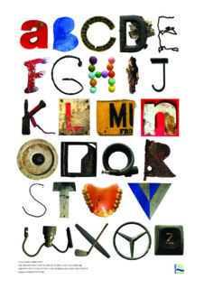
There are people who love London’s dirty rivers: magnet fishing and mudlarking are popular activities. Volunteer groups also clear rubbish from the rivers of London that are easy to access and therefore to pollute. The illustrator Jane Porter joined one such group some years ago, and her efforts resulted in a Wandle Alphabet (2011), a poster made up of objects she found in the Wandle over five years of monthly clean-ups. They include a fish-and-chip shop sign (the letter F), an Indian figurine (I), two bike locks (J and Q), a set of false teeth (U) and a typewriter key (Z). Salmon fishing remains a distant prospect, but there’s plenty to find in these waters.

Comments
Re Dickens - did Jacob's Island feature in Our Mutual Friend?